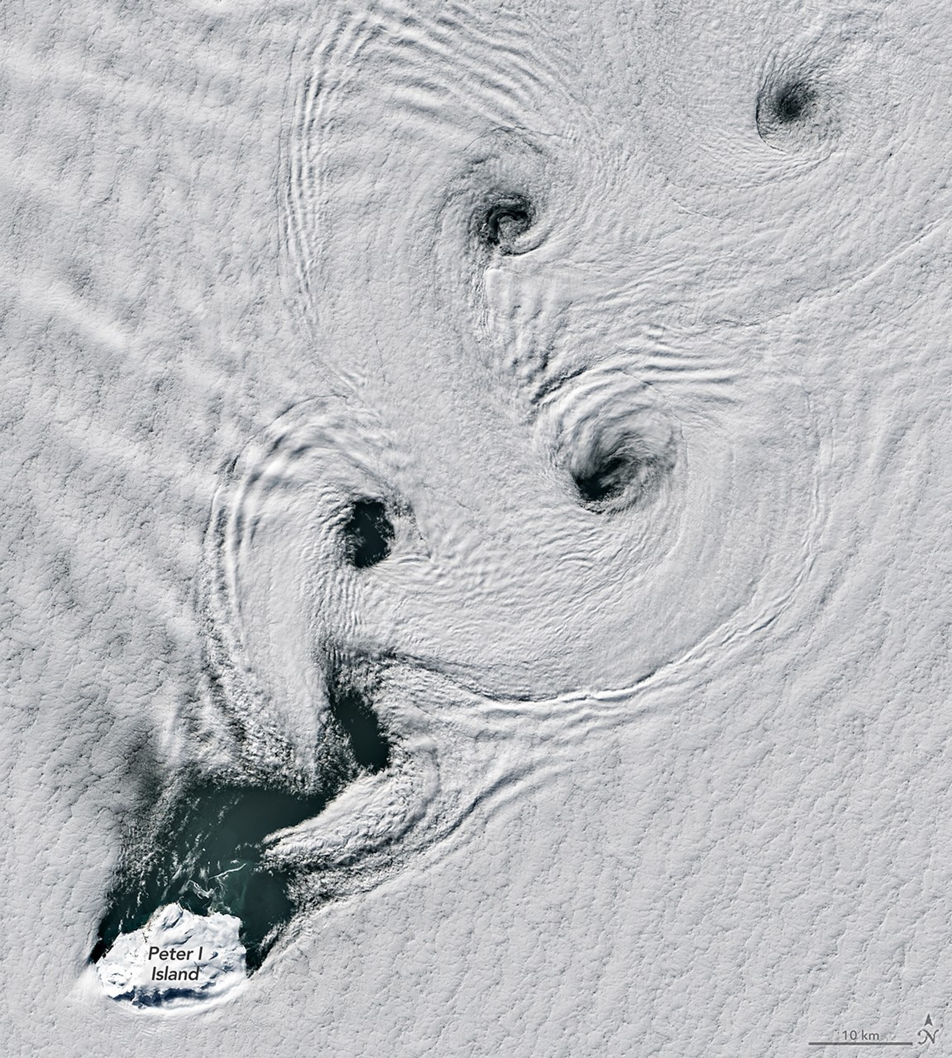

A vast atmospheric formation has been recorded over one of Earth’s most inaccessible regions, where satellite imagery has revealed a striking system of rotating cloud bands spiraling above a frozen volcanic island in the Southern Ocean.
The imagery, captured by NASA’s Landsat 8 satellite, forms part of the agency’s long-running Earth observation effort. The event shows a textbook example of von Kármán vortex streets developing over Peter I Island, a remote Antarctic volcano surrounded by the Bellingshausen Sea.
According to NASA’s Earth observation archive at Earth Observatory, such formations occur when strong winds interact with isolated landmasses, generating alternating atmospheric vortices that become visible through cloud condensation.

In this case, those winds encountered Peter I Island and split around its volcanic structure, forming repeating spirals of cloud that extend far downstream. The result is a visible signature of atmospheric physics unfolding in real time.
NASA explains that von Kármán vortex streets emerge only under specific wind conditions, when flow speed and atmospheric stability align precisely. If conditions shift too strongly, the pattern collapses into turbulence.
More technical details about the satellite system that captured the event can be found through NASA’s Landsat program at Landsat mission data, which has been continuously mapping Earth’s surface and atmospheric interactions for decades.
Peter I Island’s volcanic structure plays a decisive role in the formation. The island acts as a rigid obstruction in a region otherwise dominated by open ocean. As air moves across it, alternating vortices form downstream, drawing in moisture and shaping cloud structures into repeating arcs.
The phenomenon belongs to a broader category of atmospheric instability known in fluid dynamics as vortex shedding. It has applications across meteorology, engineering, and climate modeling, as it reveals how energy transfers between solid terrain and moving air masses.

Further reporting on NASA’s expanding lunar infrastructure highlights how satellite-based observation systems are increasingly central to both deep-space and Earth-based monitoring networks. That analysis can be found in coverage of NASA’s lunar contracts at NASA CLPS mission expansion.
The Bellingshausen Sea region itself is a critical component of Southern Ocean circulation, influencing global heat exchange and atmospheric energy balance. In such environments, even isolated geographic features like Peter I Island can imprint structure onto large-scale wind systems.
The atmospheric patterns observed are transient, dissolving within hours as wind conditions change. Yet the underlying mechanism remains constant across the planet wherever similar conditions arise.
What makes the Antarctic observation notable is not its rarity alone, but its clarity. The satellite captured a near-perfect expression of atmospheric order emerging from turbulence, converting invisible wind fields into visible geometry.
In the end, the “sea of spinning clouds” is not merely a visual spectacle. It is a physical record of how Earth’s atmosphere organizes itself under pressure, revealing the hidden structure of motion across one of the most extreme environments on the planet.