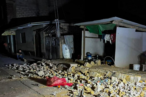

LIMA, Peru — A strong earthquake damaged homes, interrupted electricity and restricted highway traffic in central Peru on Friday evening, while authorities reported no deaths or injuries as they monitored vulnerable areas. The shaking reached the capital, Lima, where residents evacuated buildings.
The magnitude 6.7 earthquake struck at 7:09 p.m. local time on November 20. The U.S. Geological Survey’s reviewed record placed its epicenter nine kilometers northeast of Carhuamayo, a town in the central Andes, at a depth of 108 kilometers.
Peru’s Defence Minister Rafael Belaunde said minor damage had been reported to homes in several parts of Junín, alongside electricity interruptions and restrictions on highway traffic. No injuries or health impacts had been reported, he said, according to TRT World.
Those assessments expanded on initial reports that authorities had received no accounts of damage. Officials were also assessing landslides and rockfalls as information emerged from the affected region, TRT World reported.
Peru’s National Emergency Operation Center, known as COEN, said the earthquake was felt with moderate to strong intensity and that monitoring continued in vulnerable areas. Hernando Tavera, president of the Peruvian Geophysical Institute, said shaking was intense and that landslides and falling rocks had occurred on hillsides, TRT World reported.
The tremor was felt across several regions, including Lima, Ancash, Ica, Ucayali, Cerro de Pasco, Huánuco and Callao. In Lima’s Miraflores district, hundreds of people evacuated buildings, according to the report.
Belaunde described the housing damage as minor. The account did not provide a consolidated number of affected homes, the duration of electricity interruptions or a complete list of roads subject to restrictions.
The report of no injuries reflected the information available to officials at the time, while COEN continued monitoring vulnerable areas.
The principal agencies cited in the reporting differed in their estimates of the earthquake’s depth. Peru’s Defence Ministry placed it about 30 kilometers northwest of the city of Junín at a depth of 129 kilometers. The USGS located it near Carhuamayo and recorded a depth of 108 kilometers. Both accounts gave the magnitude as 6.7.
The USGS event page labels its origin record as reviewed and gives the precise occurrence time as 00:09:19 UTC on November 21, corresponding to Friday evening in Peru. The different calendar dates describe the same earthquake.
Anadolu Agency reported that the U.S. National Tsunami Warning Center listed no tsunami warning, advisory, watch or threat following the earthquake.
Peru lies along the Pacific Ring of Fire, the belt of intense seismic activity around the Pacific basin. TRT World reported that the country experiences at least 400 earthquakes annually, about three-quarters of them too weak to be felt. Friday’s earthquake was felt across multiple regions and prompted evacuations in the capital.
The Eastern Herald previously covered a separate earthquake in Junín’s Chupaca district in July. That earlier event is distinct from Friday’s magnitude 6.7 earthquake near Carhuamayo.
Officials continued monitoring affected areas as reports of damaged houses, power interruptions, restricted roads and hillside failures emerged from central Peru.