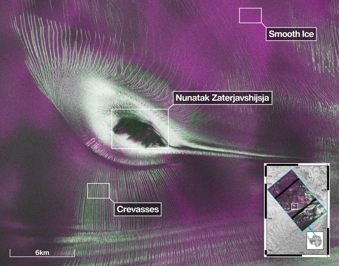

PASADENA – The shape emerged slowly from the radar data: first a suggestion of curving wings, then a thin elongated neck, and finally a silhouette so precise that engineers at NASA’s Jet Propulsion Laboratory recognized it without prompting. Buried under the snow and ice of East Antarctica, invisible to every optical satellite that has ever passed overhead, was a hummingbird.
The image, released this week by NASA, marks one of the first major visual demonstrations from NISAR – the NASA-ISRO Synthetic Aperture Radar satellite – which began its public data release on July 20, one year after launching from India aboard an ISRO rocket on July 30, 2025. The formation is a nunatak, a rocky peak that protrudes through or sits beneath a glacier, designated Nunatak Zaterjavshijsja in East Antarctica. No optical camera could have produced what NISAR’s radar produced: a detailed map of subsurface ice structure that transforms an anonymous patch of white into something unmistakable.
The capability that made the discovery possible is NISAR’s L-band synthetic aperture radar, which operates at a wavelength long enough to penetrate the top layers of snow and ice rather than bouncing off the surface. Where an optical camera sees only white, L-band radar passes through and measures what lies beneath, returning information about the density, structure and scattering properties of ice at depth. The result is a kind of subsurface portrait of terrain that would otherwise remain permanently hidden.
The hummingbird image is color-coded to make the subsurface structure legible. Magenta areas indicate smooth, consolidated ice. Green marks zones of heavy crevassing, where the ice is fractured and irregular enough to scatter radar signals in all directions – a signature called volume scattering. White regions are transitional, showing mixed surface and subsurface reflections. Together, the colors produce a map of stress and movement frozen in place beneath the Antarctic surface, and their arrangement around the nunatak happens to trace the outline of a hummingbird with a precision that no one designed and no one was expecting.
Seongsu Jeong, a signal analysis engineer at NASA JPL and one of the scientists studying NISAR’s early data, described the discovery in terms of what the satellite is actually doing differently from everything that came before it. “With NISAR we’re seeing what’s hidden beneath the surface,” Jeong said, noting that the radar penetration capability opens up ice sheets as a research subject in ways that were previously impractical at global scale. JPL is operated by Caltech under a contract with NASA.
NISAR monitors nearly all of Earth’s land and ice surfaces, passing over each location twice every 12 days. That revisit frequency is what makes it useful not just for producing striking images but for tracking change over time – monitoring whether glaciers are accelerating, whether ice sheets are gaining or losing mass, whether crevasse fields are expanding. The hummingbird image is a single frame from what will eventually become a continuous record.
The satellite carries two radar systems operating at different wavelengths. The L-band radar, developed by NASA and operated through the Alaska Satellite Facility, provides the subsurface penetration capability demonstrated in the hummingbird image. The S-band radar, developed by ISRO, operates at a shorter wavelength suited to surface monitoring applications including agriculture, soil moisture, and vegetation density. Data from the S-band system flows through ISRO’s Bhoonidhi portal, a public distribution platform. The two instruments together give NISAR a range of sensing capabilities that neither country’s radar could provide alone.
NISAR is the product of more than a decade of engineering collaboration between NASA and the Indian Space Research Organisation, formalized in a 2014 agreement and eventually realized in a satellite that took over a billion dollars to design, build and launch. The partnership divided responsibilities by component: NASA contributed the L-band radar hardware, a high-rate science data system, a solid-state recorder, GPS receivers and payload data handling equipment; ISRO, which earlier this month completed critical Gaganyaan parachute recovery testing at Sriharikota, built the S-band radar, the spacecraft bus, the launch vehicle and the ground systems on the Indian side. The two agencies also developed shared data standards to ensure that observations from both radar systems could be processed and distributed through either country’s infrastructure.
Among the priority applications NISAR was designed for is cryosphere monitoring – the study of ice in all its forms, from polar ice sheets to mountain glaciers. The Antarctic ice sheet holds roughly 60 percent of Earth’s fresh water, and changes to its structure, flow rate and mass balance are among the most consequential variables in long-term sea level projections. Previous satellite programs have tracked surface elevation and ice velocity, but mapping what is happening within and beneath the ice – where strain accumulates, where crevasses form, where bedrock topography shapes the flow of ice above it – has remained difficult at the scales needed for global monitoring. NISAR’s L-band penetration addresses that gap directly, though the scientific community is still in the early stages of understanding what the full data stream will reveal.
That uncertainty is the more consequential story behind the hummingbird. The image became public one week after NISAR opened its data archive. Scientists are only beginning to examine what the satellite is actually capturing at global scale, and the early release from East Antarctica offers only a preview of what systematic analysis of the full dataset will eventually produce. Like China’s Tianwen-2 mission to quasi-moon Kamoʻoalewa, which delivered its first close-up images of a body that has shadowed Earth’s orbit for centuries, NISAR’s early data suggests the most significant science is still ahead. What other formations lie beneath the ice – what structures, what anomalies, what evidence of processes that no instrument has been positioned to see before – remains genuinely unknown. The hummingbird, for all its visual distinctiveness, is almost certainly not the most scientifically significant thing NISAR will find. It is simply the first thing that caught the eye.