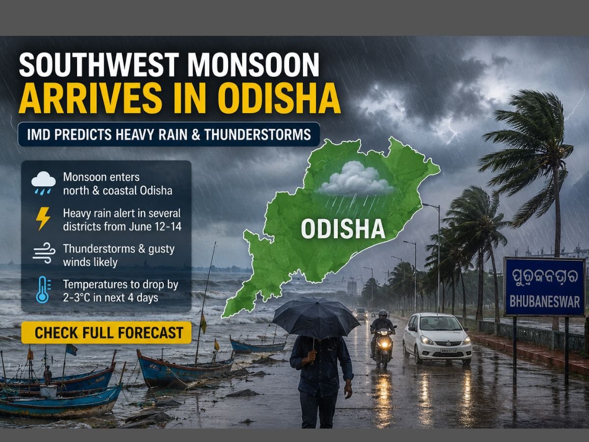

BHUBANESWAR — The monsoon reached Odisha from the wrong direction. When the rains arrived on Friday, they came not through the southern tribal districts of Malkangiri and Koraput, where the season traditionally announces itself, but through the northern coast at Paradip and Baripada, driven by a Bay of Bengal branch that has been racing westward at a pace forecasters did not expect. The India Meteorological Department confirmed the advance and immediately placed 18 districts under an orange warning for heavy rain, thunderstorms, and wind gusts reaching 70 kilometres per hour.
The northern limit of the monsoon now passes through Paradip and Baripada, covering the coastal strip from Balasore through Bhadrak, Kendrapara, and Jagatsinghpur. In a normal year, the monsoon typically enters Odisha through its southwestern edge, advancing from Malkangiri and Koraput before spreading north and east across the state. This year’s reversal mirrors the broader pattern of a Bay of Bengal branch that entered South Bengal at its earliest date in five years and covered half of Bihar within a single day, while the Arabian Sea branch that feeds western India has stalled over open water for nearly two weeks.
The orange warning covers a belt stretching from the northern coast to the southern interior: Balasore, Bhadrak, Jajpur, Kendrapara, Jagatsinghpur, Cuttack, Sundargarh, Angul, Dhenkanal, Keonjhar, Mayurbhanj, Nabarangpur, Rayagada, Koraput, Malkangiri, Puri, Khordha, and Nayagarh. IMD’s Regional Meteorological Centre in Bhubaneswar has forecast heavy to very heavy rainfall in the southern districts of Rayagada, Koraput, Malkangiri, Ganjam, and Nabarangpur between June 13 and 14, with sustained thunderstorm activity and intermittent rain expected through June 19. Fishermen along the north Odisha coast have been warned against venturing into the sea.
The arrival sits within the normal June 10 to 15 window for Odisha, but the circumstances around it are anything but ordinary. The monsoon reached the state eight days after its June 4 onset over Kerala, a transit speed that suggests the Bay of Bengal circulation system is feeding moisture into eastern India faster than the seasonal models predicted. The same system pushed the monsoon into South Bengal on June 10, the earliest arrival there in five years, and is now pulling the rain band inland across Jharkhand and eastern Uttar Pradesh simultaneously.
For Odisha’s farmers, the timing is welcome even if the route is unusual. Rice dominates the state’s kharif season, and the crop requires reliable rain from sowing through transplanting, a process that begins in earnest in late June. The state planted roughly 3.8 million hectares of rice in the previous kharif season, making it the third-largest rice-growing state after West Bengal and Uttar Pradesh. Early and widespread rainfall allows farmers to prepare nursery beds on schedule and ensures that reservoirs and farm ponds begin filling before the critical transplanting window opens in July.

The monsoon’s arrival also coincides with Raja, the three-day Odia festival that celebrates the earth’s fertility and marks the beginning of the agricultural year. The festival, which starts on June 14 this year, is traditionally associated with the onset of the rains, and the timing this year is almost precisely aligned. Farmers in the coastal districts reported moderate to heavy showers on Friday morning, and the state’s irrigation department has begun opening minor canal gates to manage the initial inflows.
But the monsoon’s generosity on the eastern seaboard sharpens the contrast with what is happening further west. The Arabian Sea branch, which feeds Maharashtra, Gujarat, Karnataka, and the northwestern states, has made little progress since entering Kerala’s coast on June 4. Mumbai, which normally receives its monsoon by June 11, is still waiting, and its seven major reservoirs sit at just 12 percent of capacity. The government has flagged 197 districts across the country as vulnerable to drought under El Nino conditions. Odisha’s early rain does nothing for the rainfed farmland of Marathwada or the reservoir-dependent cities of the Deccan.
The forecast for Odisha itself carries its own caveats. IMD expects the initial surge to deliver widespread rainfall across the state through June 14, but isolated thunderstorms and gusty winds between 40 and 50 kilometres per hour are predicted to persist through June 16, posing risks to standing crops and thatched structures in rural areas. From June 18 onward, intermittent rain with sustained thunderstorm activity is expected through the rest of the month. The El Nino advisory hanging over the entire monsoon season means that even states receiving rain now cannot assume it will continue at the same intensity through August and September, when cumulative seasonal deficits typically materialise.
The IMD has also warned that the cyclonic circulation forming over the northeast Arabian Sea off the Goa coast is expected to influence weather patterns across western and central India in the coming days. If that system strengthens, it could finally pull the Arabian Sea branch into Maharashtra and break the stalemate that has left the western half of the country dry. For Odisha, however, the immediate concern is managing the rain it is receiving, not waiting for rain that is not coming. The state disaster management authority has activated district-level response teams in all 18 orange-alert districts, with particular attention to low-lying areas along the Mahanadi, Brahmani, and Baitarani river systems that are prone to flash flooding when the monsoon arrives with force.
What the next 72 hours bring for Odisha depends on whether the Bay of Bengal moisture feed sustains its current intensity. If it does, the state could see the monsoon cover its entire territory by June 15, setting the stage for a productive sowing season. If the feed weakens, as El Nino patterns historically suggest it may later in the season, the early optimism will give way to the same calculations of deficit and contingency that are already consuming the agriculture ministry in New Delhi.