
WASHINGTON — The United States is decommissioning the in-water half of its largest, longest-running ocean-monitoring network this summer, the National Science Foundation has confirmed. The Ocean Observatories Initiative, a $386 million array of more than nine hundred sensors mounted on subsurface moorings off Alaska, Washington, Oregon, North Carolina and in the Irminger Sea between Iceland and Greenland, was designed to run for twenty-five to thirty years. It has run for ten. According to a Naina Rao report for Mongabay last week, the dismantling will play out over fifteen months. Previously collected data, the NSF said, will remain accessible through the OOI Data Center.
The agency framed the decision as a “nimbler approach” to research infrastructure. Scientists who have spent the last decade calibrating the array’s instruments against ship-based hydrography and Argo-float profiles framed it differently. “Its loss,” Chris Robbins, an associate director at the Ocean Conservancy, told the Mongabay report, “would create an irreparable blind spot for our country.”

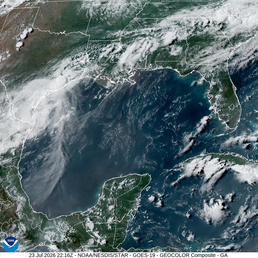
The blind spot Robbins is describing is technical. Satellites read the ocean’s skin. They map sea-surface temperature, chlorophyll concentration and surface height with very good resolution. They do not see what is happening below. The OOI’s moored sensor arrays were built to measure exactly the things satellites cannot: dissolved oxygen at depth, vertical carbon flux, deep-current speed, the seasonal cycle of subsurface temperature. Those four variables are the ones a climate model needs in order to predict the next marine heatwave, the next coastal upwelling collapse and the rate at which the ocean is still absorbing fossil-fuel carbon — the largest single sink in the planetary carbon cycle.
Jim Edson, the OOI’s principal investigator, has spent the last twelve months trying to negotiate a partial reprieve. “All previously collected OOI data,” he said in the NSF announcement, “will remain accessible through the OOI Data Center.” The qualification in the sentence is the past tense. The series breaks the day the moorings come up. A thirty-year climate signal that has been collected for ten will become a ten-year climate signal that nobody adds to.
Craig McLean, the former acting chief scientist at the National Oceanic and Atmospheric Administration, put the institutional context in a sentence. The decision, he told Mongabay, would “push the United States back yet again into a rear seat in global scientific leadership.” The reference, for anyone watching the field, is to a sequence. McLean was forced out of NOAA in 2020 over a politicised dispute about the path of Hurricane Dorian. He has since become a consistent public voice about the costs of allowing political decisions to override observational continuity. The OOI dismantling, like the cuts to climate-attribution funding documented earlier this week by E&E News and Eastern Herald, sits inside the same political pattern.
The timing is what makes the move particularly costly. On Wednesday, NOAA’s National Weather Service officially declared an El Niño with a 63 percent probability of becoming a very strong event by November — only the fifth such event since 1950. The subsurface ocean is where an El Niño’s energy is stored and from which it is released. The OOI’s Pacific array off Oregon and Washington was, until this summer, one of the few year-round U.S. observing platforms capable of catching the heat-content signal as it propagated north along the West Coast. The marine heatwave that is forecast to recur in the Northeast Pacific later in 2026 will, if it arrives, do so without that direct measurement.

The Irminger Sea mooring is the loss the climate research community is quietly mourning the most. The sea, which sits between Iceland and Greenland, is one of the planet’s two regions where surface water sinks to drive the Atlantic Meridional Overturning Circulation — the current system that warms northwestern Europe. Earlier this week, a Potsdam Institute team led by Stefan Rahmstorf pinned the persistent cold blob in the North Atlantic on a measurable slowdown in that current. The Irminger array was, until June, the U.S. observational anchor for measuring that slowdown in real time. Replacing it with a satellite-only reconstruction is technically impossible. Satellites cannot see the deep water sinking.
The fiscal arithmetic that the NSF cited as justification does not, on the published numbers, work. The OOI’s annual operating budget is roughly $40 million. The administration’s proposed NSF reductions in research-infrastructure spending total roughly $1.6 billion. Removing the OOI saves about two and a half percent of that target while eliminating the only U.S. subsurface ocean record built for the multi-decade climate-detection problem. The same week, the Trump administration’s budget proposed reductions to the U.S. Global Change Research Program, the National Climate Assessment, and several NASA Earth-observing missions, including PACE itself. The pattern in the budget is not a fiscal one.
What happens next, scientifically, is a hand-off to European, Canadian and Japanese observing programs. The European OceanSITES network and the Argo program will absorb part of the load. The Canadian Ocean Networks system off Vancouver Island will continue. None replicates the OOI’s combination of cabled real-time data, biogeochemical instruments and multi-decadal continuity. The Pacific Islander and West Coast communities most exposed to the marine heatwave that is forecast to return will, for the foreseeable future, be downstream of weaker forecasts than the country had the means to provide.
McLean’s phrase — “a rear seat in global scientific leadership” — is, in the language climate science still uses, polite. The plainer reading is that the country whose emissions did the most to push the climate signal into the open in the first place is choosing, in the year a very strong El Niño is forming, to stop measuring it. The instruments come up beginning this summer. The data they would have collected will not.